This is our take on what Barnet needs to provide for cyclists and enable active travel. There are three components: an efficient Cycle Network linking Low Traffic Neighbourhoods containing School Streets.
An efficient cycle network

This map shows our Streetspace 1st priorities in green, 2nd in orange and 3rd in red. Click to see the full ‘Barnet-required cycling network‘ map, on which can also see (by unhiding layers in the menu):
- A full cycle network, colour coded to show current suitability for cycling
- Primary schools
- Secondary Schools & Colleges
- Shopping and major Businesses
- Sports Centres
- Hospitals & Health Centres
- Tube and Rail Stations
These are the key destinations that would be served by a decent cycling network.
Low Traffic Neighbourhoods

We believe every residential neighbourhood should be designed to eliminate rat-runs ad through traffic. TfL agrees and our Barnet Streetspace map shows TfL’s Strategic Neighbourhoods. There are a few gaps in TfL’s model, which was generated automatically based on rules that included a maximum cell size, so we have attempted to fill in the gaps.
That makes 94 possible LTNs and the good news is that 22 already have no through traffic. Existing point closures are shown on the map (green dots). But 3/4 of them can be used by through traffic. The map shows several traffic hot spots inside LTNs (red dots).
See our page ‘Why does Barnet need Low Traffic Neighbourhoods‘.
Read: LTNs for all? Mapping the extent of London’s new Low Traffic Neighbourhoods
Read: Despite a loud opposing minority, low-traffic neighbourhoods are increasingly popular
Read: Sustrans’ introductory guide to low-traffic neighbourhood design and LCC’s guidance on LTNs to both policy makers and officers
School Streets
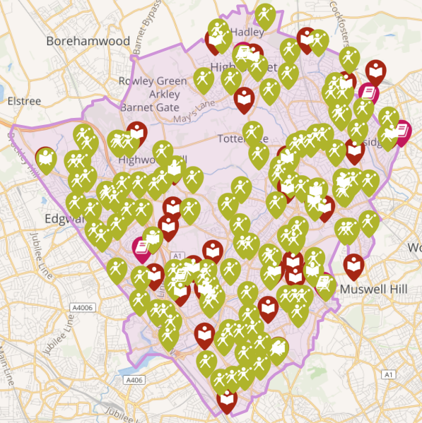
We have mapped some 188 places of education on the ‘Barnet-required cycling network‘ map. To see them click in the menu to reveal the 125 Primary Schools and 63 Secondary Schools & Colleges.
We believe their locations should be assessed to provide temporary restrictions on motorised traffic at school drop-off and pick-up times.
The good news is that Barnet were granted funding in July 2020 for their first School Streets.
Coupled with safe cycle routes to school in Low Traffic Neighbourhoods they could eliminate most of the ‘school run’ traffic, cut pollution and encourage walking and cycling to school.
Background: How we designed our cycle network
Back in 2017 we illustrated the quality of a Barnet cycle network by devising a colour-coded “Tube map”. The idea was originally developed by the Bristol Cycle Campaign, and then built on by neighbouring Cycle Bath. Like the famous London Tube map, these maps use bright colours to depict a representation of the local network.

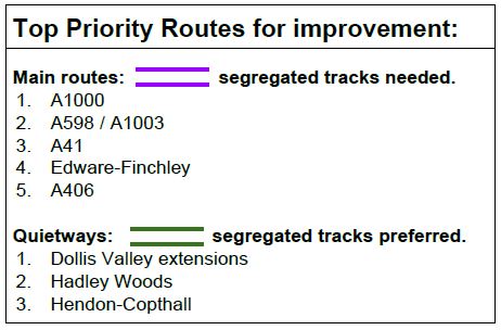
Unlike the London Tube map, the colours in these maps are used to demonstrate the gaps in the network. The general rule is that blue routes are safe and comfortable; either separated from motor traffic or on quiet, 20 mph roads. Other colours denote varying degrees of danger. The result was the original Cycle Network Quality Map for Barnet (PDF 500Kb). Our latest version is now available by revealing the colour coded layers in our ‘Barnet-required cyling network‘ map
Network Opportunities
Our map acts as a useful prompt to show local residents and decision makers the quality of the current cycle network and where the gaps need plugging. In doing so, it demonstrates the importance of planning an entire network and helps to establish where investment should be prioritised.
For example, if you look at the map for where you live, is there an entirely blue route going between your home and your workplace? Or between your home and your child’s school? Probably not, which is why so few people choose to cycle for these journeys.
Councils have been asked to plan cycle networks as part of the Government’s Cycling and Walking Investment Strategy and to seek funding to get infrastructure on the ground. The Mayor of London[1] aims for 70% of Londoners to live within 400 metres of a high-quality safe cycle route.
In preparing our map we looked at key residential areas and destinations on this Google map. We examined TfL paper maps showing recommended cycle routes, looked at Propensity to Cycle based on 2011 census data and then connected nodes using reasonably direct routes, based on local knowledge.
We converted this to a schematic ‘tube map’; colour coded it based on safety and highlighted our top priorities. TfL’s Strategic Cycling Analysis and Rapid Cycleway Promotion Tool shows similar priorities for mainly radial cycle commuter routes, while our map fleshes this out with more cross routes and local connections.
Problem Junctions
A key step towards creating safer cycling routes is to make junctions more cyclist friendly. We have identified some of the worst junctions and other problem areas in Barnet on a separate map.
The London Assembly report ‘Hostile Streets – Walking and Cycling at Outer London Junctions’ shows that a change in culture is needed, prioritising people, not cars, on London’s streets.
Updates
[1] Mayor’s draft Transport Strategy, Proposal 3.
